Neenach Volcano from Wikipedia

Rock
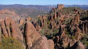
formations at Pinnacles NP
Neenach Volcano is an extinct Miocene volcano in the Coastal
Ranges of California. After formation, the volcanic field was split by a fault
in the San Andreas Fault Zone, and over the last 23 million years, the two
halves of the volcano have moved about 195 miles apart.
The correlation of the two portions,
now called the Pinnacles and Neenach volcanic formations, is significant; this
correlation has become a “classic example” of plate tectonics for geologists.
Ten rock types with nearly identical field, petrographic, and chemical
characteristics are present in each formation in essentially the same stratigraphic order. This
provides ample evidence for the correlation and interpreted movement along the
San Andreas Fault.
The volcano formed 23 million years
ago during tectonic
subduction of the
oceanic Juan de Fuca Plate
beneath the continental North American Plate, a
process often associated with volcanic eruptions near the plate boundaries.
Subsequent complex geophysical mechanisms caused a segment of the Juan de Fuca
Plate to fuse to the eastern edge of the adjoining Pacific Plate, ending
subduction and initiating horizontal shear movement between the plates, with
the Pacific Plate moving northwesterly and the North American Plate moving in
the opposite southeast direction. This transform movement began approximately
20 million years ago and the resultant shear lineation is the San Andreas Fault
Zone. The Neenach Volcano was situated directly over the primary San
Andreas fault, causing it to be split in two once the transform fault movement
began. The average relative motion along the fault is about 1.5 cm per
year, equivalent to six inches per decade. Over the course of this movement,
the two halves of the volcano drifted about 195 miles apart and eroded down
into the minor rock formations visible today.
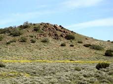
The
area where the Neenach volcanics are found covers 40 km2, west of
the Mojave Desert, but the only visible remains are a few outcroppings on
hills, comprised of red-colored andesite. Being on private land, they can only
be viewed from some distance.
Neenach is one of those small towns no
one has ever heard off. From Palmdale, there is a choice of two routes to get
there. One is the straight west from
Lancaster across the featureless Antelope Valley plain. A few Joshua trees
provide the only scenery. The second
route follows the slower but more pleasant Elizabeth Lake Road west out of
Palmdale, through a straight narrow valley, just behind one of the ridges. The
road runs between nice-looking houses and goes past Hughes Lake. The valley
narrows to just a few tens of meter in places while you begin to wonder about
this peculiar valley. Turns out that you’re following the San Andreas Fault
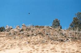
thru this valley. The road takes you up into the hills, past wonderful trees. In
these hills near Three Points & CA-138 are the eroded remnants of the
Neenach Volcano. As you drop back down onto Antelope Valley you’ll cross the
California Aqueduct .
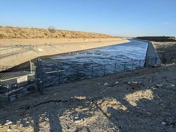
California
Aqueduct carries Sierra Nevada water from the Sacramento-San Joaquin
Delta up north!
Okay, geology quiz… Which side of that Miocene volcano is
Pinnacles NP (about 195 miles north of Palmdale)? Hint: Check out our scenic drive at: CA 25 Road Trip1
Answer: Pinnacles
NP is on the Pacific Plate west side of north-south trending CA 25 or SAF. So
the Neenach volcanic formation in Palmdale is on the North American Plate or
east side of the San Andreas Fault.